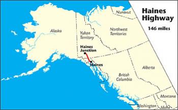
 Connects: Haines, AK, to Haines Junction, YT
Route#: Yukon 3, Alaska Route 7
Length: 153 miles
Road Surface: Paved
Season: Open all year
Highest Pass: Chilkat Pass, elev. 3,510 feet
Map (1 detailed pdf file available):
Haines, AK to Haines Junction, YT
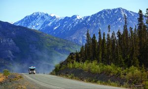
The 153-mile/246-km Haines Highway connects Haines, Alaska, at the head of Lynn Canal, with Haines Junction, Yukon, on the Alaska Highway. Open year-round, and usually snow-free by late May, it is a good, 2-lane paved highway. Driving time is 3–4 hours.
Noted for its grand views of glaciated mountains and the variety of its scenery—from coastal forests to alpine tundra—the Haines Highway was awarded National Scenic Byway status in 2009.
The Haines Highway winds through the Chilkat River flats outside Haines before beginning a long climb up to Chilkat Pass (elev. 3,510 feet), where it crosses a wide alpine valley then descends into Haines Junction via a series of long, easy grades. It accesses the Chilkat Bald Eagle Preserve; skirts Tatshenshini–Alsek Wilderness Provincial Park; and follows the eastern border of Kluane National Park and Reserve.
Part of what is now the Haines Highway was originally a “grease trail” used by the coastal Chilkat First Nations trading eulachon oil for furs from the Interior. In the late 1880s, Jack Dalton developed a packhorse trail to the Klondike goldfields along the old trading route. The present road was built in 1943 as a military access highway during WWII to provide an alternate route from tide-water into Yukon.
Communities

The MILEPOST® Quick Reference Log
Miles from Haines (H) and from Haines Junction (HJ) shown.
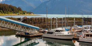
H 0 HJ 152.9 HAINES; all visitor services. Junction of Main Street (Haines Highway) and Front Street. Small boat harbor to south on Front Street, Oceanside RV Park to north. Alaska Fjordlines Express is at the northeast corner of this intersection.
H 0.1 HJ 152.8 The Hammer Museum northeast of 2nd Street. Take second street for Captain’s Choice Motel.
H 0.6 HJ 152.3 Haines Hitch-Up RV Park; full-service sites, laundromat. Entrance is on Main Street.
H 8.3 HJ 144.6 Entering Alaska Chilkat Bald Eagle Preserve northbound.
H 21.5 HJ 131.4 Turnoff via paved access road for KLUKWAN (pop. 61), a Chilkat Alaska native village. and the Jilkaat Kwaan Heritage Center and Bald Eagle Preserve Visitor Center.
H 27.2 HJ 125.7 Emerson Field and skate park at turnoff on Mosquito Lake Road for Kroschel Wildlife Center at Mile 1.8.
H 33.1 HJ 119.8 33 Mile Roadhouse; gas/diesel, cabins, hamburgers.
H 40.2 HJ 112.7 Port of Entry: Dalton Cache U.S. Customs and Border Protection. All travelers entering the United States MUST STOP. U.S. customs is open daily from 7 a.m. to 11 p.m. (Alaska time). Southbound travelers cannot drive south to Haines if the customs station is closed. Phone 907-767-5511. Restrooms, large parking area. The historic Dalton Trading Post (behind customs station) was originally the men’s quarters for the NWMP Dalton Detachment in 1898. The international boundary line was redefined in 1900, and the structure ended up on the U.S. side.
H 40.4 HJ 112.5 U.S.–Canada border.
H 40.6 (65.5 km) HJ 112.3 (180.5 km) Pleasant Camp Canada Customs and Immigration office. All travelers entering Canada MUST STOP here. Canada customs is open daily from 8 a.m. to midnight (Pacific time). You cannot drive north into Canada if the customs station is closed.
H 63.5 (102.2 km) HJ 89.4 (143.8 km) Paved viewpoint to west at Haines Highway Summit (elev. 3,510 feet/1,070m), Chilkat Pass.
H 90.4 HJ 62.5 BC–YT border.
H 98.8 HJ 54.1 Turnoff for Yukon government Million Dollar Falls Campground
H 113.8 (183.2 km) HJ 39.1 (62.8 km) Historic Milepost 118 at turnoff for Klukshu, a First Nations village.
H 121.6 HJ 31.3 Entrance to a sometimes rut-filled loop road for Yukon government Dezadeash Lake Campground.
H 136.5 HJ 16.4 Turnoff to west for Kathleen Lake Campground, the only established campground within Kluane National Park.
H 152.9 HJ 0 HAINES JUNCTION; all services.